- About
- Affiliates
- Join
- Publications
- Estuaries and Coasts
- CERF's Up! Quarterly Bulletin
- Coastal & Estuarine Science News (CESN)
- CERF-Lit
- Advertising
- Programs & Events
- Inclusive Culture
- Communities
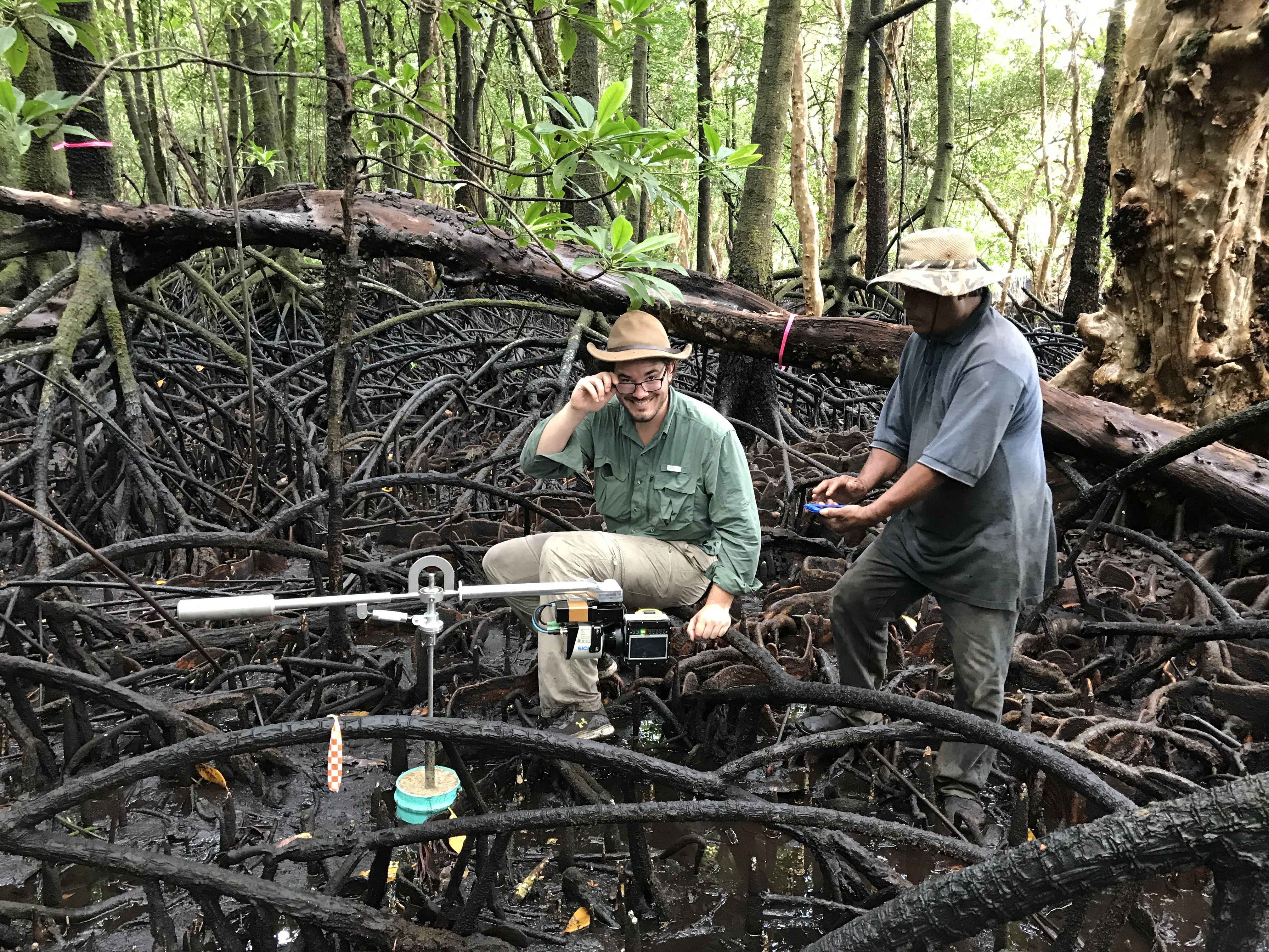
Coastal & Estuarine Science News (CESN)The mission of Coastal & Estuarine Science News (CESN) is to highlight the latest research in the journal Estuaries and Coasts that is relevant to environmental managers. It is a free electronic newsletter delivered to subscribers on a bi-monthly basis. Sign up today! 2024 Issue 2Table of ContentsAssessing Elevation in Mangrove Forests Assessing Elevation in Mangrove Forests Surface elevation tables, lead-210, or compact biomass LiDAR?
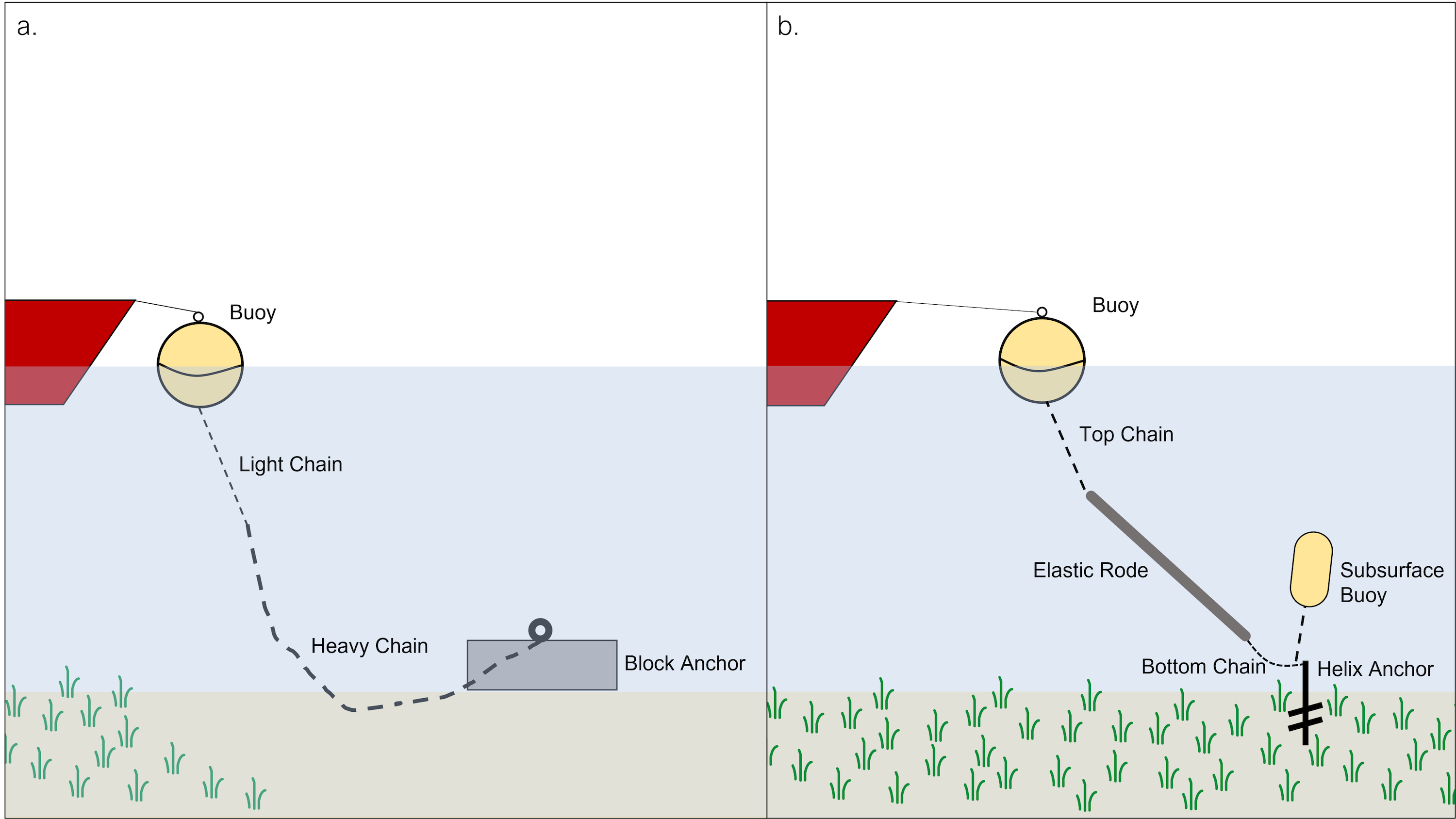
In a paper that’s part of a special issue on wetland elevation dynamics, researchers conducted a direct comparison of 3 methods for measuring surface elevation and accretion in mangrove forests on the island of Pohnpei in Micronesia. The dataset included observations from surface elevation tables (SETs) at 17 monitoring sites measured regularly from 1999 to 2017; cores collected at each of the sites in 2016 that used radionuclides (210Pb) to estimate long-term accretion; and compact biomass LiDAR (CBL), which was used at a subset of 8 of the plots in both 2015 and 2017. CBL is a specialized system that can collect high-density elevation information over a radius of up to 3 meters. CBL units were mounted on SETs to allow a direct comparison. All 3 methods generated comparable estimates of the annual rate of surface elevation change. However, there were advantages and disadvantages to each. Lead-210 provides surface accretion estimates over a long time horizon (centennial rather than annual to decadal scales), but each core takes time and specialized equipment to process. Traditional SETs are the least expensive, but they have a limited lifespan and require precise surface measurements by humans to estimate elevation that generates error. CBL generates data at a much finer resolution (measuring 30,000 points per plot compared to 36 SET measurements) and is completely automated, but generates large datasets that require hours of processing. The paper includes a table with the pros and cons of each approach, including price estimates. Source: MacKenzie, R.A. et al. 2023. Relative Effectiveness of a Radionuclide (210Pb), Surface Elevation Table (SET), and LiDAR At Monitoring Mangrove Forest Surface Elevation Change. Estuaries and Coasts. DOI: 10.1007/s12237-023-01301-y Image: LiDAR / Richard MacKenzie Are Environmentally Friendly Moorings Better for Seagrass? Yes, but they require long-term maintenance.
The team observed eelgrass revegetation in most of the scars following the switch. However, 5 years post-conversion, few scars experienced complete recoveries, and there remained unvegetated areas with an average radius of 2 meters around the anchor. While the density of recovered eelgrass in the scars wassimilarto that of unscarred areas, percent cover was one-third lower. The team also observed CMS gear dragging on the bottom and impacting eelgrass when the system was too big for the depth of the site and also when they became covered by fouling organisms. Although conservation mooring systems can be a useful tool for reducing the impact of moorings on eelgrass beds, routine maintenance and cleaning are required, and it’s important to consider site characteristics before installing these systems. Because eelgrass recovery following the switch was variable and nearly always incomplete, the conversion of mooring systems alone is insufficient for eelgrass restoration. Conserving existing meadows and improving conditions that promote eelgrass growth, specifically in regard to water quality, will be critical for their survival under projected temperatures and sea levels. Source: Seto, I. et al. 2024. Recovery of Eelgrass Zostera marina Following Conversion of Conventional Chain Moorings to Conservation Mooring Systems in Massachusetts: Context‑Dependence, Challenges, and Management. Estuaries and Coasts. DOI: 10.1007/s12237-023-01322-7 Image: Diagrams of a conventional blockchain mooring (left) and a floating rode conservation mooring system (right) / The Authors Dredged Materials Can Help With Marsh Elevation A case study with nutrient-rich, fine-grained sediment in the Chesapeake Bay.
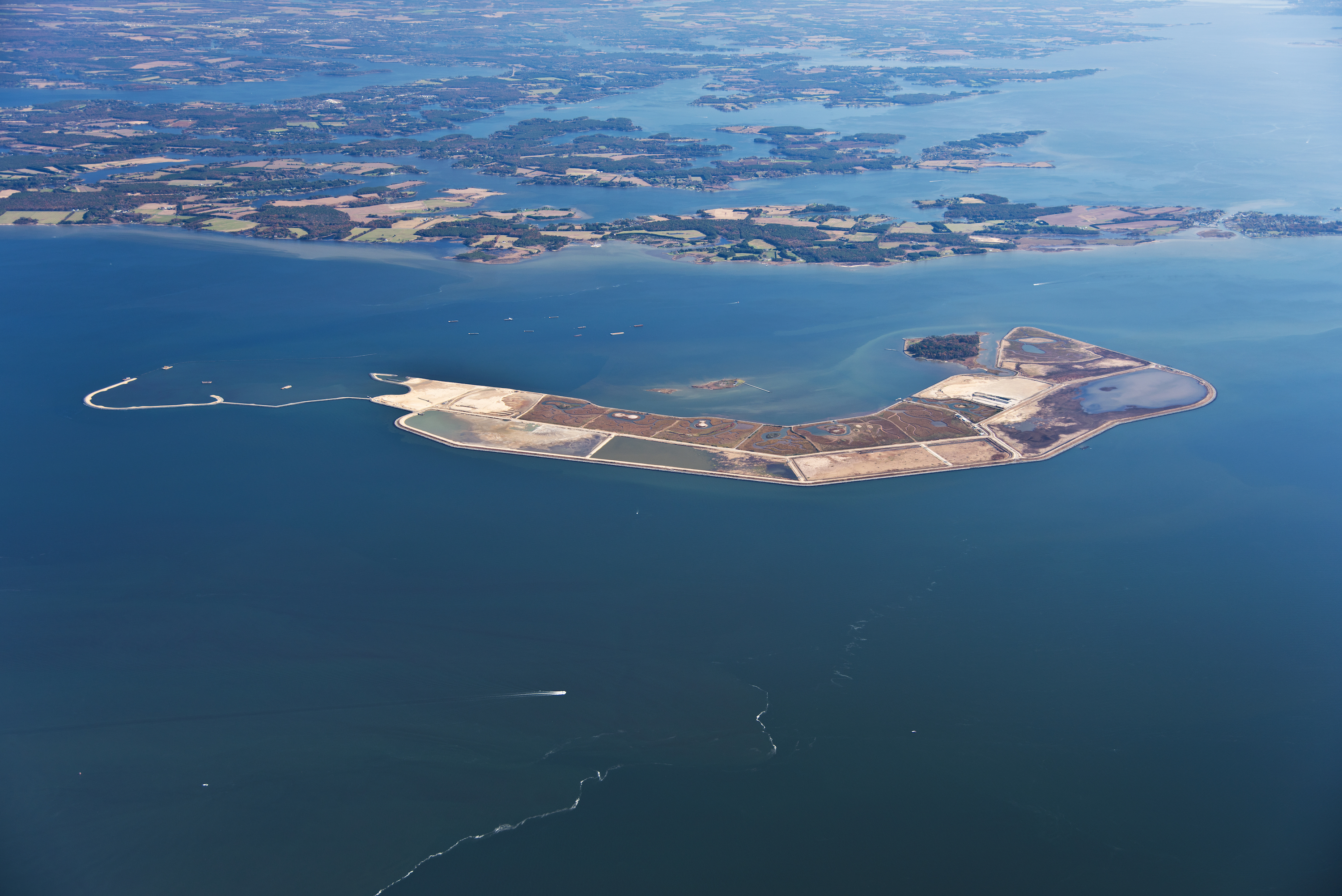
On Maryland’s Poplar Island, fine-grained, nutrient-rich dredged sediment from the upper Chesapeake Bay is being used to create 302 hectares of tidal marshes over 30 years. To inform future restoration efforts, researchers examined trends in elevation change in 7 marshes that were created from open water areas where marshes once existed. Using data from 39 surface elevation tables, they compared accretion rates in both high and low marsh areas with the local rate of relative SLR and with a nearby natural reference marsh. The nutrient-rich dredged material essentially catalyzed an increase in elevation in low marsh areas. The mean rate of elevation gain in these restored low marshes was more than double that of control areas—and it exceeded relative SLR. The critical factor in the vertical increase was belowground biomass, which contributed more to accretion than surface sediment. By stimulating high rates of organic matter production and elevation change, the substrate appears to offset the low supply of inorganic sediment in mid-Chesapeake Bay. In contrast, the mean rate of elevation gain in high marsh areas was just above that of the reference marsh. Enhancing vegetation growth and maximizing organic matter deposition are the most important contributors to elevation gain in this sediment-starved environment, and appropriate channel design may enhance deposition of inorganic sediment. According to the study, not only can fine-grained dredged material be used successfully for marsh restoration, but the nutrients contained therein accelerate vegetation establishment and appear to enhance elevation gain in the first few years. Source: Staver, L.W. et al. 2024. Elevation Changes in Restored Marshes at Poplar Island, Chesapeake Bay, MD: I. Trends and Drivers of Spatial Variability. Estuaries and Coasts. DOI: 10.1007/s12237-023-01319-2 Image: Poplar Island / USACE, Baltimore District Seascape Nurseries: Juvenile Fishes Link Multiple Habitats Broadening the paradigm of estuaries as nurseries. Estuarine and adjacent inshore habitats are important nursery areas for fishes. They’re commonly perceived as discrete, homogenous habitats promoting juvenile growth and survival and contributing recruits to adult populations in coastal and offshore habitats. However, defining nurseries as singular units may be too simplistic since it doesn’t account for dynamic processes such as juvenile movements between habitats. To determine whether this nursery-role concept needs to be refined, researchers in Australia quantified the juvenile movements of two harvested fishes in Jervis Bay Marine Park. Acoustic tags with 400 days of battery and an array of receivers were used to track 33 luderick (Girella tricuspidata) and 20 yellowfin bream (Acanthopagrus australis) between August 2018 and May 2021, recording a total of 739,584 detections. The team found that both species had relatively small home ranges, and they exhibited site attachment to the seagrass meadows where they were released. However, most fish made frequent, repeated trips to creeks and rocky reefs directly adjacent to seagrass habitat. These reef-ward movements were short visits lasting days to months—likely exploratory movements that correspond to changing resource requirements and reduced predation risk as fish mature. Overall, these results demonstrate that juvenile fish routinely use and connect multiple habitat types—which support broadening the nursery concept from single habitats to a mosaic of interconnected habitat patches, or seascape nurseries. Gaining a more quantitative understanding of nursery function and the movement patterns of juveniles will help improve knowledge on species–habitat linkages and better inform the design of conservation strategies such as marine reserves. Multiple habitats should be conserved for juvenile survival, and the variety of habitats should be in close proximity to enable connectivity and increasing extension of home ranges as fish grow. Source: Swadling, D.S. et al. 2024. Consequences of Juvenile Fish Movement and Seascape Connectivity: Does the Concept of Nursery Habitat Need a Rethink? Estuaries and Coasts. DOI: 10.1007/s12237-023-01323-6 |